Posts

Showing posts from 2019

Stokes State Forest Recap

Image
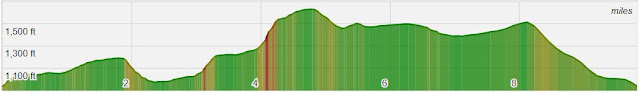
Thanks to everyone who braved the 26 degree weather at the trail-head!  And special thanks to the new hikers who came out as well, it was great to meet each of you.   Luke rated this hike an 8 out of 10 and while we may quibble with the values, I think we can all agree it was a great way to spend a Saturday. My Strava stats match the predicted length and elevation for the first time in our history - 10.19 miles with a 1,472 total elevation game - well done!  And further, I promise once Brian stops distracting me I will do better at making correct turns at trail-head junctions. Our Relive video is below (click YouTube when the video starts to make it larger). And our photo album is here (and linked to the right) with some few highlights below. Taking a rest at a junction Mike and Fred showing how nimble they are during a dangerous stream crossing Proof it was cold Getting on the AT Gibbs on top of the world Bob and Zack keeping warm on Sunrise Mou

Hike #12 - Stokes State Forest

Image
Hike Date - Saturday, November 16th (This is our second attempt, the first, scheduled for this pass summer had to be canceled) For this hike we'll head to a northwest NJ staple, Stokes State Forest, a 16,000 acre woodland nestled in the Kittatinny Mountains.  Many long-time NJ residents likely have taken an overnight middle school trip the cabins in the valley.  The pay-off is a great view from Sunrise Mountain, the second tallest 'peak' in New Jersey at 1,653 feet above sea level. Length - Appx 10.1 Miles Elevation Gain - ~1400 feet Difficulty - Moderate to Challenging Expected Duration - 4-7 hours Park Trail Map - Stokes State Forest  or courtesy of NYNJTC Our Route - Here Parking Location - Stony Lake Parking - arrive via main Stokes entrance, drive down Coursen Rd and make a right at the end to get to the trail lot. (Follow signs for Stony Lake).  GPS Coordinates:  41.203732, -74.772489 and Google Maps link Restrooms - At the visitors center on the way

Harriman State Park II Recap

Image
Thanks everyone for yet another great day in the woods!  The weather was good, the hike was great, the company even better.  This was our 13th hike and were a mere three feet away from an unlucky 13, but luckily Karen did not step on that rattler. Looks like we hiked about 8.5 miles with an elevation gain 1,800 feet, not shabby at all, well done all.  And a special thanks to our new hiker Olivia, who along with Luke did there best to keep our average age to a workable number. The obligatory Relive video (click YouTube when the video starts to watch on YouTube in a larger format(.... And finally, some pictorial highlights below.  Here is the album , feel free to add directly to this from your device or desktop, or if easier you can email or text them directly to me.  (Click to enlarge) The long line of hikers making there way through the wild (courtesy of Bob) Two wonderful group pics from Ramapo Torne  Brian did a lot of complaining about Ramapo Torne, but

Ramapo Torne and Racoon Brook Loop in Harriman State Park

Image
On Sunday, October 6th we'll head back to Harriman State Park to try a different set of trails in the Southern section of the park.  It's approximately an 8 mile loop with 1,600 feet of elevation gain, and features a fun spot to climb, the famous view at Ramapo Torne, and several cascades if the water is still flowing.  We can also see the NYC skyline a in a few spots to if conditions are favorable. There are multiple bail out points or options to extend as well.  Start time is 9:30 AM as it is a bit of a drive for most in the group. Length - Appx  7.5 Miles Elevation Gain - ~1500 feet Difficulty - Moderate to Challenging Expected Duration - 4-6 hours Park Trail Map - Harriman State Park Our Route - Here Parking Location - Russian Bear Trail-Head Parking (41.174149, -74.168819) and there is a lot a few hundred feet up the road on the left (88 Seven Lakes Drive, Southfield, NY will get you close).  Note:  This is a very popular starting point for several hikes i

Schunnemunk Mountain Recap

Image
Thanks everyone for another great day.  The weather was excellent, the views wonderful, and the company top notch.  My route app said 6.9 miles with 1,500 feet of elevation gain, my legs call this into question as they are fairly tired at the moment! Album here and linked to the right, send me any pictures you would posted and I'll include them as well. Through the tall grass He needs no introduction First views - Hudson River and Storm King Mountain Break time at the top Some minor scrambles that made the route even more enjoyable What is Jeff drinking?  (Thanks Brian for your back and the barley malt!) Take 3 was the winner From the megalith One of a few small cascades I believe Gibbs asked us to stop, we didn't need the cool water ourselves Back through the field

Hike #12 - Schunnemunk Mountain State Park

Image
On Saturday, June 8th we'll return to Schunnemunk Mountain State Park.  A few regulars were not able to make this hike last year, so lets try it again with a partially different route.  We'll tackle Stokes next fall/winter in order to avoid the $20 per car fee to enter. Schunnemunk has a lot to offer:  an open meadow section, a huge megalith, numerous scrub pines scattered among open bedrock, and a distant view of the Hudson River and Storm King Mountain.  It can also be easily lengthened or shortened depending upon how every is feeling. Of historical note, there was some fighting inside the park boundary during the Revolutionary War and Schunnemunk (pronounced Skun-uh-munk) means "excellent fireplace" in Algonquin.  It is also the highest point in Orange County, NY. Length*  - Appx  9 Miles Elevation Gain  - ~1600 feet Difficulty  - Moderate to Challenging Expected Duration  - 4-7 hours Park Trail Map  -  Schunnemunk Mountain State Park Our Route  - Here

Sunfish Pond Recap

Image
Wow, this hiking group keeps on upping it's game.  On the last hike in Harriman we set a new group record for length, and on Sunday, we topped it again, tromping 12.3 miles and almost 2,500 feet in elevation gain.  Hopefully everyone had seconds at dinner! While enjoyable, it was also a bit sketchy at times, with multiple slippery stream crossings, two wet hikers, and a 3rd set-out to prove the iPhone 8+ is truly waterproof.  Still, we persevered, congratulations to all.  Personally, I can't wait to try this route again in the spring or fall. Here is the Relive video... On to the pictures, some highlights below (click to enlarge) and the full  album  is permanently linked on the right of the blog. An early look at Dunnfield Creek The 1st crossing A picturesque section of trail alongside the creek Up Up Up A frozen Sunfish Pond Gibbs smelling Lou's bacon breath Brian captured break time Lou's attempt at a chest selfie

Hike #11 - -RESCHEDULED - Sunfish Pond in the Delaware Water Gap

Hike Date - Sunday, January 20th   New Date - Sunday, February 10th To start our 3rd season we'll tackle our 1st ever winter hike, and return to a starting location of our 1st trail in the Delaware Water Gap National Recreation Area.  Sunfish Pond is a 44 acre glacial lake nestled atop the Kittatinny Ridge in Worthington State Forest and one of New Jersey's eleven designated National Natural Landmarks. Length - Appx 8.1 Miles Elevation Gain - ~1200 feet Difficulty - Moderate to Challenging Expected Duration - 4-6 hours Park Trail Map - Worthington State Forest Our Route - Here Parking Location* - Dunnfield Parking off Route 80, just before River Road and 8/10 of a mile before the bridge.  Great  diagram  from njhiking.com - Main Lot is the preferred lot Restrooms - There have been port-a-potty's at the Parking Lot, but then again not always.  There is a visitor center about 1/2 mile away, but that also may be closed in the off-season.  Safest bet is rest s