Hike #12 - Schunnemunk Mountain State Park
On Saturday, June 8th we'll return to Schunnemunk Mountain State Park. A few regulars were not able to make this hike last year, so lets try it again with a partially different route. We'll tackle Stokes next fall/winter in order to avoid the $20 per car fee to enter.
Schunnemunk has a lot to offer: an open meadow section, a huge megalith, numerous scrub pines scattered among open bedrock, and a distant view of the Hudson River and Storm King Mountain. It can also be easily lengthened or shortened depending upon how every is feeling.
Of historical note, there was some fighting inside the park boundary during the Revolutionary War and Schunnemunk (pronounced Skun-uh-munk) means "excellent fireplace" in Algonquin. It is also the highest point in Orange County, NY.
- Length* - Appx 9 Miles
- Elevation Gain - ~1600 feet
- Difficulty - Moderate to Challenging
- Expected Duration - 4-7 hours
- Park Trail Map - Schunnemunk Mountain State Park
- Our Route - Here
- Parking Location - 17 Taylor Rd, New Windsor, NY 12553 or 41.407626, -74.081855. GPS highly recommended.
- Restrooms - I don’t recall seeing bathroom facilities, but there is a gas station near Woodbury Commons on Route 32.

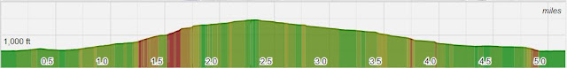
This route is similar to our hike last spring, with the main change being the route to the ridge itself. Once atop the ridge, it follows much of our previous path. The most challenging section of the hike is the 1,000 ft gain starting around the 1.0 mile mark. While there is no scrambling, it is steep and the leg burn continues for a good mile or more.
It's well worth it though, the ridge-line is the main highlight as the trail takes past multiple viewpoints, a megalith, and exposed bedrock sections scattered with glacial erratics and pitch pine trees. For those familiar with Norvin Green and Abram S Hewitt State Forest, I like to think of it as a suped-up version of similar sections found in those parks.
*A note on mileage. The Hiking Project App predicts and 8 mile journey, my instincts tell me this is closer to 10, so I split the difference and labeled it 9. Many apps smooth out the route a bit, and the ridge line itself has many small turns that are probably not being picked up well by the app algorithm.
Blazes and Mileage
- 5.4 M - Jessup Trail (Yellow)
- 1.6 M - Dark Hollow Trail (Black)
- 1.1 M - Sweet Clover Trail (White)


Comments
Post a Comment