Posts

Showing posts from 2021

Hike # 17: Terrace Pond Loop in Wawayanda State Park
Image
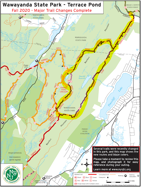
Hike Date:  Saturday, July 10 Postponed Our last route was intentionally on the easy side to help get everyone back into the swing of hiking.  This time we up the difficulty a full notch with an 8 mile route through Bearfort Ridge and into Wawayanda State Park.  The loop is called Terrace Pond north has some rock scrambling, a few nice viewpoints, and a scenic (though sometimes crowded) pond. Neither Lou, Jeff, or Karen have hiked this one so let's discover together! Start Time - 9:00 AM Length - Appx 8.0 miles Elevation Gain - ~1,100 feet Difficulty - Moderate with Difficult, rocky sections Expected Duration - 4-5 hours Park Trail Map - Trail Map Parking Location – Side of the road on Warwick Turnpike, West Milford, NJ:   41.15744782812143, -74.36746903484052 Restrooms – None at the trailhead, best option is one of the Gas Stations on Route 511 Our Route:

A Successful Return to the Trail!

Image
Thank you hikers for an enjoyable morning!  I clocked 6.1 miles with 879 feet of elevation gain, with a total moving time of 2 hours and 46 minutes.   We battled some cold rain and wind, and then enough sun that I did get a little burn by the time we made it back to the trailhead. Our photo album is here and linked to the right, please continue to add any pictures you want to share. Below are some of the photo highlights and the Relive video. (Click to enlarge for better viewing)

We're Back!! Hike #16 - Racoon Ridge (Mount Mohican) via the AT

Image
Hike Date – Sunday, May 2nd. It’s been an incredibly long 14 months since our last AT&T hike, but with the weather looking good and vaccine distribution on the rise, we feel it’s safe enough to head back out on trail in groups.  We do need to follow park guidelines for mask wearing – please bring a mask in case it is needed in crowded areas or if we are in structures such as bathrooms or visitors centers. We’ll get things started on a lovely hike along the Appalachian Trail in the Delaware Water Gap, trekking our way to Racoon Ridge and making a loop out of the return.  This is your typical New Jersey AT experience – rocks, rocks, and rocks with an incredible view north along the river as the main reward.  There are a few other vista points along the way as well not to mention some lovely hardwood forest scenes to enjoy too. Start Time - 9:00 AM Length - Appx 6.5 Miles* Elevation Gain - ~800 feet* Difficulty - Moderate (though challenging if we extend*) Expected Duration - 3-5 hour