Great first hike of 2020 - good trail, great weather, superb people. Thanks everyone for joining us!
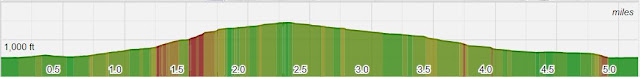
The good news - I clocked 5.2 miles with 1,130 feet of elevation gain. The bad news - my net calories by the afternoon was a gain of 200 after that lunch at the Sycamore Grille.
Also of note this the first hike that came in with few miles than expected, we're getting better at this.
The photo album is linked to the right and please contribute if you can. Or if easier you can send me directly as well.
Obligatory Relive Video (Viewing in Full Screen is Much Better
Harriman State Park Relive Video Congratulations to everyone who completed the Harriman Hike! That was a full day of hard work, fresh air, and trail navigation. Our stats varied depending upon tracker, but we clocked somewhere between 10.2 - 11.2 miles, enjoyed an elevation gain between 2,100 and 2,600 feet, and get this ... took 27,500 steps, at least according to Stacey's tracker. Regardless, this hike squarely ranks first in length, total ascent, and duration - the sun was just setting behind the mountain as the last group was crossing the field to the Elk Pen parking lot. Highlights were extensive, here are just a few Everyone made it back! A few got a little lost and at one point Lou headed down the wrong trail, but for such an extensive trail system we did very well. Special thanks to Sheila for her keen eyes and Barbara for her cartography skills. Everyone completed the rock scramble, awesome job! Not sure if it was peer pressure or w...
Hike Date - Saturday, February 22nd For this hike we'll head back to where it all began.... sort of. Instead of hiking to the summit of Mt Tammany as we did in our first hike, we'll take in some great views of Tammany as we hike to the summit of her sister, Mount Minsi. This hike is entirely on the Pennsylvania side of the Delaware Water Gap and additional highlights of this route include a few minor rock scrambles, and a lovely Rhododendron tunnel (or 2, or 3), and a better than average fire road. We'll also test our navigation skills by ending on a lovely un-blazed section called Table Rock Start Time - 9:00 AM Length - Appx 5.9 Miles (It's winter!) Elevation Gain - ~1000 feet Difficulty - Moderate to Challenging Expected Duration - 3-5 hours Park Trail Map - NPS Trail Map Our Route - Our Route Parking Location - A gravel lot off of Lake Road in Bangor, PA. GPS Coordinates: 40.979850, -75.142087 and...
We are hiking right above where the Hudson Rover is no longer visible on the map (go to Manhattan, look at the squiggly curve line north of it, where are a few miles north of where the small curve ends). The ground will undoubtedly be wet from all the rains this week, but the shower activity looks to be limited enough to still hike. As Jeff said, I will post something early tomorrow morning if the hike is canceled, but for now it remains a go.


Thanks for another fun hike!
ReplyDelete