Hike #6 - Return to Norvin Green State Forest - Back On for Sunday 4/29!
Our first hike for the 2018 season will be a return to Norvin Green State Forest in Ringwood, NJ, at 9:00 AM on Sunday, April 29th. We attempted this hike last May, but a poor weather forecast kept most of us at home and only a few stalwarts braved the rain. This hike is arguably the best in NJ, it seems appropriate to kick off the year in style. There are several attractions – 360 degree views of the areas including the NYC skyline on a clear day, a river, a waterfall, and some boulder hopping. Despite being nestled in central Passaic County, the 5,400 acre size of the park also gives the hiker the opportunities for that coveted backwoods feel.
To want to come back! Norvin Green has a vast system of trails, each with its own unique style, and this route is just a taste of what the park has to offer. This hike highlights some of the best of them, but as a result, the trail switching also makes it easier than normal to get lost. In fact, last year we had a momentary moment of panic when a group member accidentally skipped a section, causing the rest of the group to think they were lost. Please print a map (linked above) and familiarize yourself with our route ahead of time.
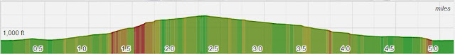
The route itself is varied and moderately challenging. The hike starts with a 450 ft single-track climb past a cascade and a few interesting viewpoints as we ascend the “mountain”. Approximately one mile into the hike we’ll encounter our first gem – Wyanokie High Point. Accessed via a fun and minor rock scramble up and across exposed bedrock, the summit is spotted with pitch pines, overlooking the Wannaque Reservoir and offering views of the surrounding mountains – Assiniwikam, Buck, and Saddle. The summit has 360 degree vistas of the entire area and should be explored on all sides, a just a deserving reward for the steep section trail just completed.
Many people turn around here but our day has luckily just started. We’ll backtrack down the summit a tenth of a mile and head south for Carris Hill. The mile+ journey is relatively easy with sections of quick but sometimes steep hills, more exposed bedrock, and through typical NJ hardwood forest. The top of Carris Hill is about 1,100 ft above sea level and opens up with interesting glacial erratic’s spotting the area and some more of those lovely scrub pine bushes. The trail descends 600 ft in ¾ of a mile (better down than up!) and has a great place to pause to take in another outstanding view of the reservoir. If your so inclined, you can traverse a huge outcrop as well, the perfect place to take in a view of the New York City skyline in the distance.
The next section takes us through low lying wet areas and a great view of Posts Brook, a sometimes swift and wide flowing stream through the southern section of Norvin Green. Moments later we’ll arrive at Chikhoki Falls, a picturesque cascade that the trail follows to it’s top. Here we’ll soon change direction and head north, through a great 1 ¼ mile section of Wyanokie Crest trail, which follows a minor tributary of Posts Brook and ads a double log stream crossing to the adventure. This is also where we’ll “boulder hop” across a marshy area before heading back up to an elevation of 1,100 ft.
The rest is easy, a downhill 1.6 mile leg back to the parking area. This wide section of trail is one of the most used in the park and follows a good portion of the base of Assiniwikam mountain, including some unique rock formations and a final stream crossing.
Mileage and Blazes
0.3 Miles - Green-Otter Hole
0.8 Miles - Blue-Hewitt Butler:
0.1 Miles - Red-Wyanokie Circular (Up/Down)
0.9 Miles - Blue-Hewitt Butler
0.9 Miles - Yellow-Carris Hill
0.5 Miles - White-Lower & Posts Brook
0.3 Miles - Blue-Hewitt Butler
1.3 Miles - Yellow-Wyanokie Crest
1.7 Miles - Green-Otter Hole
Parking Note and Directions
There is no cell service in the Parking Area. If you need directions you will not be able to reach Jeff, Karen, or Lou for advice. Please use a GPS if possible, the trailhead is accessed through back roads only.
There are no restrooms in Norvin Green State Forest. If this is a concern, there are gas stations and a Quick check on Rt 511.
- Follow Our Route on Your Phone with the Hiking Project App
- Difficulty – Moderate to Challenging
- Length – 7.5 Miles
- Elevation Gain – several up and down sections, 1,600 ft total
- Expected Duration – 4-6 hours
- Park Trail Map (bad link fixed 4/10)
- Our Route
- Parking Location – 140 Snake Den Road, Ringwood, NJ (41.069837, -74.321617) – see note below.
To want to come back! Norvin Green has a vast system of trails, each with its own unique style, and this route is just a taste of what the park has to offer. This hike highlights some of the best of them, but as a result, the trail switching also makes it easier than normal to get lost. In fact, last year we had a momentary moment of panic when a group member accidentally skipped a section, causing the rest of the group to think they were lost. Please print a map (linked above) and familiarize yourself with our route ahead of time.
The route itself is varied and moderately challenging. The hike starts with a 450 ft single-track climb past a cascade and a few interesting viewpoints as we ascend the “mountain”. Approximately one mile into the hike we’ll encounter our first gem – Wyanokie High Point. Accessed via a fun and minor rock scramble up and across exposed bedrock, the summit is spotted with pitch pines, overlooking the Wannaque Reservoir and offering views of the surrounding mountains – Assiniwikam, Buck, and Saddle. The summit has 360 degree vistas of the entire area and should be explored on all sides, a just a deserving reward for the steep section trail just completed.
Many people turn around here but our day has luckily just started. We’ll backtrack down the summit a tenth of a mile and head south for Carris Hill. The mile+ journey is relatively easy with sections of quick but sometimes steep hills, more exposed bedrock, and through typical NJ hardwood forest. The top of Carris Hill is about 1,100 ft above sea level and opens up with interesting glacial erratic’s spotting the area and some more of those lovely scrub pine bushes. The trail descends 600 ft in ¾ of a mile (better down than up!) and has a great place to pause to take in another outstanding view of the reservoir. If your so inclined, you can traverse a huge outcrop as well, the perfect place to take in a view of the New York City skyline in the distance.
The next section takes us through low lying wet areas and a great view of Posts Brook, a sometimes swift and wide flowing stream through the southern section of Norvin Green. Moments later we’ll arrive at Chikhoki Falls, a picturesque cascade that the trail follows to it’s top. Here we’ll soon change direction and head north, through a great 1 ¼ mile section of Wyanokie Crest trail, which follows a minor tributary of Posts Brook and ads a double log stream crossing to the adventure. This is also where we’ll “boulder hop” across a marshy area before heading back up to an elevation of 1,100 ft.
The rest is easy, a downhill 1.6 mile leg back to the parking area. This wide section of trail is one of the most used in the park and follows a good portion of the base of Assiniwikam mountain, including some unique rock formations and a final stream crossing.
Mileage and Blazes
0.3 Miles - Green-Otter Hole
0.8 Miles - Blue-Hewitt Butler:
0.1 Miles - Red-Wyanokie Circular (Up/Down)
0.9 Miles - Blue-Hewitt Butler
0.9 Miles - Yellow-Carris Hill
0.5 Miles - White-Lower & Posts Brook
0.3 Miles - Blue-Hewitt Butler
1.3 Miles - Yellow-Wyanokie Crest
1.7 Miles - Green-Otter Hole
Parking Note and Directions
There is no cell service in the Parking Area. If you need directions you will not be able to reach Jeff, Karen, or Lou for advice. Please use a GPS if possible, the trailhead is accessed through back roads only.
- Take Route 287 to exit 55 (511/Wanaque/Pompton Lakes)
- Turn right onto Ringwood Ave and follow 4 miles
- Turn left onto W Brook Road/Westbrook Rd and follow 2 miles
- Turn left onto Snake Den Rd and stay left (not onto Dale Rd) and follow .6 miles to parking lot Meet-up locatio
There are no restrooms in Norvin Green State Forest. If this is a concern, there are gas stations and a Quick check on Rt 511.


Comments
Post a Comment