Hike #2 proved to be more challenging than expected, but hopefully it was more rewarding as well. We beat the forecasters and ended up with fairly nice weather as the rain held out until later in the afternoon, after we were finished. In all, 5 of us made the hike which was anywhere between 7.2 and 9.2 miles long, depending upon the tracking software we utilized. Either way, it was longer than I predicted and we'll double and triple check distances going forward.
Some quick highlights and lessons learned:
The route was definitely slick and three of us, including yours truly, took a spill. Always check your footing!
Beware of scraggly looking raccoons that are out during the day and not afraid of people.
Enjoy the small things - colorful centipede's, orange newt's, and spring wildflowers.
And the big - Wyanokie High Point, Carris Hill, Chikahoki Falls, and rock hopping along a stream bed and the surrounding wetlands.
But bring bug spray, especially in the moist areas
Most importantly, we also learned to walk with at least one other group member at all times. At one point a member of our group went missing and a healthy dose of concern set in for all but the "lost" person. In the end it turned out they were ahead of everyone else and not lost, but if it hadn't been for cell phone service (which isn't usually reliable) the hike would have turned into a search.
Thank you for those that attended! This was a good enough hike that we'll put it on the list later this year for a re-hike, perhaps in the fall with the foliage is at it's peak.
Some photo's below (Thanks Jilana for sharing!) As with last time, click one to enlarge and you can then cycle through.
Thank you to all who joined us! Our first ever meet-up was a success and we working on a follow up. The weather was almost perfect - it worked for the climb (1250 ft) but was a tad uncomfortable with the wind at the summit. The trail was in moderate condition as there was plenty of water and mud to work our way around, especially in the second half on the blue trail. We lucked out a bit too - Dunnfield Creek was flowing swiftly and made for a scenic rest spot. Special thanks to Darlene who realized a large group of our members was at a different parking lot! Rick brought some technology into play, here is a nifty video of our route based upon his GPS software which ties our coordinates against a three dimensional elevation profile of our hike: And here is our gallery. Click any image and it will pop out for larger view, and allow you to scroll through each more easily. Thank You Jeff and Rick for sharing. Our Route via Rick's GP...
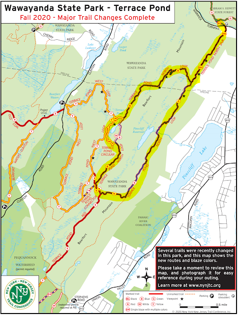
Hike Date: Saturday, July 10 Postponed Our last route was intentionally on the easy side to help get everyone back into the swing of hiking. This time we up the difficulty a full notch with an 8 mile route through Bearfort Ridge and into Wawayanda State Park. The loop is called Terrace Pond north has some rock scrambling, a few nice viewpoints, and a scenic (though sometimes crowded) pond. Neither Lou, Jeff, or Karen have hiked this one so let's discover together! Start Time - 9:00 AM Length - Appx 8.0 miles Elevation Gain - ~1,100 feet Difficulty - Moderate with Difficult, rocky sections Expected Duration - 4-5 hours Park Trail Map - Trail Map Parking Location – Side of the road on Warwick Turnpike, West Milford, NJ: 41.15744782812143, -74.36746903484052 Restrooms – None at the trailhead, best option is one of the Gas Stations on Route 511 Our Route:
Harriman State Park Relive Video Congratulations to everyone who completed the Harriman Hike! That was a full day of hard work, fresh air, and trail navigation. Our stats varied depending upon tracker, but we clocked somewhere between 10.2 - 11.2 miles, enjoyed an elevation gain between 2,100 and 2,600 feet, and get this ... took 27,500 steps, at least according to Stacey's tracker. Regardless, this hike squarely ranks first in length, total ascent, and duration - the sun was just setting behind the mountain as the last group was crossing the field to the Elk Pen parking lot. Highlights were extensive, here are just a few Everyone made it back! A few got a little lost and at one point Lou headed down the wrong trail, but for such an extensive trail system we did very well. Special thanks to Sheila for her keen eyes and Barbara for her cartography skills. Everyone completed the rock scramble, awesome job! Not sure if it was peer pressure or w...


Looks like it was a great hike with nice challenges. Much greener than Tammany too! Glad it's a candidate for re-hike later this year!
ReplyDeleteGood point on the green - the tammany pics are all brown-hued, what a difference a month makes!
ReplyDelete