Hike #10 - Harriman State Park
Hike Date - Sunday, November 11th
Harriman State Park is a huge 47,000 acre NY Park in the Lower Hudson Valley. It is extremely popular with good reason - 200 miles of hiking trails with boating, fishing, and swimming in over 30 lakes. With the weather cooling off we thought it was time to tackle one of our most challenging hikes yet - about 7.5 miles in length with multiple ups and downs. The reward is worth it though, as the route traverses the historic Appalachian Trail and Long Path and in the process brings us through some fascinating scenery and a challenging rock scramble.
Harriman State Park is a huge 47,000 acre NY Park in the Lower Hudson Valley. It is extremely popular with good reason - 200 miles of hiking trails with boating, fishing, and swimming in over 30 lakes. With the weather cooling off we thought it was time to tackle one of our most challenging hikes yet - about 7.5 miles in length with multiple ups and downs. The reward is worth it though, as the route traverses the historic Appalachian Trail and Long Path and in the process brings us through some fascinating scenery and a challenging rock scramble.
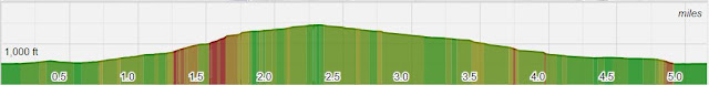
- Length - Appx 7.5 Miles
- Elevation Gain - ~1200 feet
- Difficulty - Challenging
- Expected Duration - 4-6 hours
- Park Trail Map - Harriman State Park
- Our Route - Here
- Parking Location* - Elk Pen Parking (41.264805, -74.154308)
- Restrooms - None at the trail head
What to Expect
To need a nap at the end of the day, but not to worry, if the terrain and elevation are proving too much there are multiple ways to cut this hike short. However, please don't plan on detouring by yourself unless you are very comfortable reading a map, there numerous crisscrossing trails in this park and it is very easy to get lost.
The route starts off with a heart pumping, 900 ft ascent up the Appalachian Trail that contains to steep sections. On the way there is a great resting point at Island Pond, an extremely scenic boating area just off the AT. Halfway up the second leg of this ascent is also the famous "Lemon Squeeze", and a challenging rock scramble that requires upper body strength to pull oneself up a steep set of boulders. If this is a concern, be not worried, there is an "easy" way that avoids the scramble, though still fun and challenging in and of itself.
Soon we'll veer off the AT and onto Long Path and eventually Lichen Trail, arguably the best little trail in the park. We'll end with a slow descent past an abandoned mine and through the Valley of Boulders, with challenging and interesting trails throughout.
As a group we can decide whether or not to extend by 2.5 miles or so. The extension would take in Bowling Rocks and fun other fun terrain on exposed bedrock.
Blazes and Mileage
- Appalachian Trail (east, but northbound) - 2.75 miles
- Long Path (south) - 0.7 Miles
- Arden-Surebridge Trail (east) - 0.3 Miles
- Lichen Trail (south) - 0.4 miles
- Ramapo Dunberg Trail (south) - 0.45 miles
- Dunning Trail (west) - 1.1 miles
- Nurian Trail (north) - 0.95 miles
- Stahahe Brook Trail (north) - 0.7 miles
- Arden-Surebridge Trail (north) - 0.5 miles
Parking Note: This park takes in 1.4 million visitors a year and our trail head is extremely popular. Get their early if you don't want to walk to the trail head.


Comments
Post a Comment