Hike #9 : Cliff Park in Milford, PA
"The Cliff Trail offers some of the most spectacular overlook views in the recreation area of the serpentine Delaware River valley from atop the Raymondskill Ridge. This view was so inspiring to early film makers that several westerns were filmed using this magnificent scenery as stand-ins for the landscapes out west. Early 1900s actors Tom Mix, Walter Miller and Mary Pickford are just some of the stars who once stood on these vary cliffs." .... The National Park Service
We tried to schedule this hike last fall, but the weather got ahead of us and we shut down for the winter. We hoped to start the 2018 season with this hike but nesting Peregrine Falcons closed the trails for over 6 months. Hopefully third times is a charm as we'll attempt this hike again on Saturday, September 29th.
This is an ideal beginner hike, but also will keep the regulars interested thanks to some epic cliff views and two waterfalls along the way. If that isn't enough, 2.3 miles of trail is un-blazed (not marked) and little hiked this year due to the closure, so we'll perhaps get to do some bushwhacking too.
Please contact Jeff Carlson (jc1372) if you are interested in joining us.
- Easy/Moderate - One steep incline at the start and the rest is fairly level.
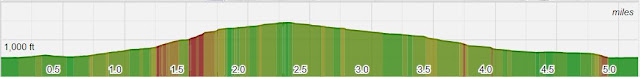
- Length - Appx 6.2 Miles (we can extend another 1.15 miles with 200 more ft elevation gain)
- Elevation Gain - ~900 feet
- Expected Duration - 3-5 hours
- Park Trail Map - Delaware Water Gap NPS
- Our Route - Cliff Park Trail Route
- Parking Location - Raymondskill Road, Milford, PA 18337 (41.290330, -74.840084). See below for note
- Restrooms - At the Parking Lot and 4.25 mile mark
What to Expect
By all accounts this should be an exciting, but not exactly challenging hike. The views are incredible and there are two large waterfalls to add to the show, but 1,000 feet elevation gain (probably less) in 6.2 miles will make this one of the easiest hike we've tackled.
We'll start by taking in the view at Raymondskill Falls, the tallest in Pennsylvania. This section is really just a walk to some viewing platforms but being this close to the falls we shouldn't pass up the opportunity to take them in.
After our fill at the falls and we'll start the real hike by tackling most difficult section is at the onset, a 350 ft gain in half a mile. This is certainly not easy, but at the same time not really close to the 1000+ feet we tackled with Mt Tammany, Buttermilk Falls, or Schunnemunk Mountain. Once atop the ridge we hike alongside the cliff edge on an unblazed trail for about 2 miles. There are constant breathtaking views in this section, some of the best in the entire area.
At the end of Cliff Park trail we will do an about face, take a trail that parallels the route we just followed, and head towards it a small pond near Cliff Park golf course, skirting the 6th hole tee box before heading back into the woods. Soon we'll arrive at Hackers Fall which isn't nearly as tall as Raymondskill, but is set in much more picturesque area. We'll have full view of the river and a back woods, evergreen feel. It's a little over a mile back to parking from here.
Note: f we are feeling spry we can extend this hike by 1.15 miles or so by heading to the Milford Knob Overlook before taking in the golf course and Hackers Falls. The trail in this section is double track and just average, but perhaps any trail is better than no trail.
Blazes and Mileage
- Cliff Park Trail - Unblazed (2.3 miles)
- Optional: Right onto Cliff Trail (north) - White Blaze to Milford Knob Overlook (1.2 miles)
- Left on Cliff Trail (south) - White Blaze (0.9 miles)
- Right onto Buchanan Trail (west) - Orange Blaze (0.15 miles)
- Right onto Pond Loop (north) - Blue Blaze (0.5 Miles)
- Right onto Buchanan Trail (west) - Orange Blaze (0.4 Miles)
- Right onto Hackers Trail (southwest) - Yellow Blaze (1.6 miles)
Note: Cliff Park Trail literally takes us next to open cliff ledges with a severe drop. There are no sections of trail that are dangerous, but please be aware of this before bring your pets or small children.
Note 2: Dogs are not allowed on the Raymondskill Falls trails. I couldn't find any information if they are allowed on the Cliff Park side.
Parking Note: There is a small dirt lot across from the trailhead. I don't have an address, so please use the GPS coordinates above. If you search Parking Lot for Raymondskill Falls on Google Maps it will take you to a lot 250 ft past the trailhead. Consider this lot overflow if it's crowded.


Comments
Post a Comment