Norvin Green State Forest - May 6th
At 9:00 AM on May 6th we'll head to Norvin Green State Forest in Ringwood, NJ. This is one of the top hikes in New Jersey and features great 360 degree views of the area, some good up and downs, and if lucky, and distant view of the New York City skyline. There are waterfalls, boulder fields, and some rock climbing for the adventurous.
Comparing this hike to our Tammany hike is difficult. Here there is nothing as steep as the Red Dot trail, but it is almost twice the length and offers it's own challenge in duration.
Please contact Jeff Carlson (JC1372) by April 30th to be added to the attendee list.
What to Expect
The first thing to realize about Norvin Green State Forest is that it's a 5,400 acre park with a vast system of trails. It is important to know where you are and have access to your maps. For our purposes we are combining several trail sections in order to take in as many of the great vistas as possible.
The hike starts innocent enough at the New Weiss Center where we pick up the Otter Hole trail (green blaze) and hold it past the Highlands Natural Pool. (Note: Other trails join the green in this area as well). This section of the hike is more like a walk through a summer camp, but I promise it improves.
After a relatively steep uphill climb leave the light green and pick up Blue/Yellow. Soon these blazes split as and we follow Blue (Hewitt-Butler) to the approach to a great vista point. When Blue intersects with Red/White we want to take a short detour up R/W to Wyanokie High Point. Here you can see panoramic views of the Wanaque Resevoir, and if we are lucky enough to have clear, arid skies, a far distant view of New York City. The "climb" up to the Point is over exposed rock, a nice treat in the NJ area.
After this vista, we back track to Blue to take in Yoo Hoo Point before reaching Carris Hill Trail, marked by a Yellow Blaze. This trail is a treat to descend with several new viewpoints of the reservoir, glacial deposits, and an optional scramble up an impressive rock ledge. Really wonderful section of the hike.
Carris Hill ends and a tricky section of map watching commences as two different white trails intersect. When Yellow ends make a right onto Lower Trail (White) and very soon after this trail ends, and make another right onto White (Posts Brook). Soon after we can rest at Chikahoki Falls, and relatively small, but wide cascade that can be quite picturesque when flowing well.
Continue on White (Posts Brook) until the Blue intersection. (This is the same Blue we left for the Carris Hill detour). Continue here until the Wyanokie Crest crosses our path where we need to make a right. This long section (Yellow) is not often used but a personal favorite of Lou's. There is boulder hopping, stream crossing, and some more views of NYC if the skies are clear.
The trail eventually joins back in with our original Otter Hole (Green Blaze) and we make our way back to the parking lot. If anyone's wants to add more distance, they can head up Buck Mountain (picture courtesy of njhiking.com) before heading back via Otter Hole Trail.
Whew! Here are the markings and mileage:
Comparing this hike to our Tammany hike is difficult. Here there is nothing as steep as the Red Dot trail, but it is almost twice the length and offers it's own challenge in duration.
Please contact Jeff Carlson (JC1372) by April 30th to be added to the attendee list.
- Difficulty - Moderate to Challenging
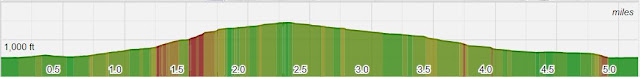
- Length - 6.0 Miles
- Elevation Gain - Several up and downs for ~1,600 ft total
- Expected Duration - 4-6 Hours
- Park Trail Map
- Our Route
- Parking Location - 140 Snake Den Road, Ringwood, NJ (41.069837, -74.321617)
What to Expect
The first thing to realize about Norvin Green State Forest is that it's a 5,400 acre park with a vast system of trails. It is important to know where you are and have access to your maps. For our purposes we are combining several trail sections in order to take in as many of the great vistas as possible.
The hike starts innocent enough at the New Weiss Center where we pick up the Otter Hole trail (green blaze) and hold it past the Highlands Natural Pool. (Note: Other trails join the green in this area as well). This section of the hike is more like a walk through a summer camp, but I promise it improves.
After a relatively steep uphill climb leave the light green and pick up Blue/Yellow. Soon these blazes split as and we follow Blue (Hewitt-Butler) to the approach to a great vista point. When Blue intersects with Red/White we want to take a short detour up R/W to Wyanokie High Point. Here you can see panoramic views of the Wanaque Resevoir, and if we are lucky enough to have clear, arid skies, a far distant view of New York City. The "climb" up to the Point is over exposed rock, a nice treat in the NJ area.
After this vista, we back track to Blue to take in Yoo Hoo Point before reaching Carris Hill Trail, marked by a Yellow Blaze. This trail is a treat to descend with several new viewpoints of the reservoir, glacial deposits, and an optional scramble up an impressive rock ledge. Really wonderful section of the hike.
Carris Hill ends and a tricky section of map watching commences as two different white trails intersect. When Yellow ends make a right onto Lower Trail (White) and very soon after this trail ends, and make another right onto White (Posts Brook). Soon after we can rest at Chikahoki Falls, and relatively small, but wide cascade that can be quite picturesque when flowing well.
Continue on White (Posts Brook) until the Blue intersection. (This is the same Blue we left for the Carris Hill detour). Continue here until the Wyanokie Crest crosses our path where we need to make a right. This long section (Yellow) is not often used but a personal favorite of Lou's. There is boulder hopping, stream crossing, and some more views of NYC if the skies are clear.
The trail eventually joins back in with our original Otter Hole (Green Blaze) and we make our way back to the parking lot. If anyone's wants to add more distance, they can head up Buck Mountain (picture courtesy of njhiking.com) before heading back via Otter Hole Trail.
Whew! Here are the markings and mileage:
- Green-Otter Hole: 0.4 Miles
- Blue/Yellow: 0.2 Miles
- Blue-Hewitt Butler: 0.7 Miles
- Red-Wyanokie Circular: 0.1 Miles Up
- Red-Wyanokie Circular: 0.1 Miles Back
- Blue-Hewitt Butler: 0.6 Miles
- Yellow-Carris Hill: 0.8 Miles
- White-Lower: 0.1 Miles
- White-Posts Brook: 0.4 Miles
- Blue-Hewitt Butler: 0.3 Miles
- Yellow-Wyanokie Crest: 1.3 Miles
- Green-Otter Hole: 1.7 Miles
Total: 6.0 Miles
Directions to Parking Lot
The route is a little off the beaten path:
Directions to Parking Lot
The route is a little off the beaten path:
- If you are using GPS the address of 140 Snake Den Road, Ringwood, NJ will work
- If you have an older GPS, you may need to put in the lat/lon coordinates (41.069837, -74.321617)
- Take Route 287 to exit 55 (511/Wanaque/Pompton Lakes)
- Turn right onto Ringwood Ave and follow 4 miles
- Turn left onto W Brook Road/Westbrook Rd and follow 2 miles
- Turn left onto Snake Den Rd and stay left (not onto Dale Rd) and follow .6 miles to parking lot Meet-up location


Comments
Post a Comment