First Hike April 8th - Mt Tammany
Our first hike!
If interested in participating please contact Jeff Carlson (JC1372) by April 1st. Please provide him with your mobile # and the best email address to communicate with.
If inclement weather is expected we'll decide to postpone by Wednesday, April 5th.
*****
At 9:00 AM on April 8th, we'll head out to the Delaware Water Gap and hike up Mt. Tammany. This is a short hike in mileage, but does put some strain on the body with sharp elevation gain. The payoff is well worth it though.
What to Expect
This is a relatively short hike but very challenging from the first step as you climb to the main vista point. It's 1250 ft over 1.5 miles, so plan to go slow at first. We'll start on the Red Dot trail and 1/2 mile in is a great view of "the Gap" with Pennsylvania on the right and New Jersey on the left.
From here is a section with some minor rock traversing before reaching the summit for another one of a kind view. The adventurous can scramble down to a ledge for another unique lookout point.
From the top, we'll pick up the Blue Dot trail for the trek back down. This is steep and rocky but no boulder hopping, and after a mile we'll pick up the green trail and follow it to some small but picturesque cascades. Continue on green over the bridge, before hooking into the Appalachian Trail and back to the parking lot.
Here is a view from the parking lot, and the rocks at the top of this picture are what we'll hike to.
Summary of Route
*Parking Note: It is very easy to miss the lot as it is not marked well and off interstate 80. There is a definite sign for Dunnfield Creek Natural Area but if you are speeding by at 65 MPH it is easy to overlook.
If interested in participating please contact Jeff Carlson (JC1372) by April 1st. Please provide him with your mobile # and the best email address to communicate with.
If inclement weather is expected we'll decide to postpone by Wednesday, April 5th.
*****
At 9:00 AM on April 8th, we'll head out to the Delaware Water Gap and hike up Mt. Tammany. This is a short hike in mileage, but does put some strain on the body with sharp elevation gain. The payoff is well worth it though.
- Difficulty - Challenging (due to grade)
- Length - 3.7 Miles
- Elevation Gain - 1250 ft
- Expected Duration - 2-4 Hours
- Park Trail Map
- Our Route
- Parking Location - Dunnfield Parking off Route 80, just before River Road and 8/10 of a mile before the bridge. Great diagram from njhiking.com. See Note Below*.
What to Expect
This is a relatively short hike but very challenging from the first step as you climb to the main vista point. It's 1250 ft over 1.5 miles, so plan to go slow at first. We'll start on the Red Dot trail and 1/2 mile in is a great view of "the Gap" with Pennsylvania on the right and New Jersey on the left.
From here is a section with some minor rock traversing before reaching the summit for another one of a kind view. The adventurous can scramble down to a ledge for another unique lookout point.
From the top, we'll pick up the Blue Dot trail for the trek back down. This is steep and rocky but no boulder hopping, and after a mile we'll pick up the green trail and follow it to some small but picturesque cascades. Continue on green over the bridge, before hooking into the Appalachian Trail and back to the parking lot.
Here is a view from the parking lot, and the rocks at the top of this picture are what we'll hike to.
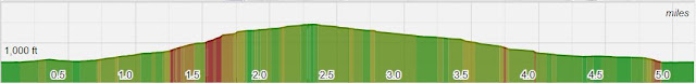
Summary of Route
- Red Dot from Parking Lot to top of Tammany (~1.5 Miles)
- Left onto Blue Dot most of return leg (~1.6 miles)
- When Blue Dot ends, turn left on to Green (~0.2 Miles)
- When Green ends turn left onto AT White (~0.4 Miles)
*Parking Note: It is very easy to miss the lot as it is not marked well and off interstate 80. There is a definite sign for Dunnfield Creek Natural Area but if you are speeding by at 65 MPH it is easy to overlook.
- The first lot is the best lot, as the red dot trail begins from here.
- If full, exit the lot and bear right and there will be a second, larger lot on your right.
- If this is full, get back on Route 80 and take the Exit for Route 1. Make a left onto River Road which goes under Route 80 and brings you to the visitor center. Here is a map if you want to additional detail. There are bathrooms here too.
- If anyone is concerned we can meet 3 miles east at the McDonald's off route 80 (4 Simpon Road, Columbia, NJ) and carpool to the trailhead.


There's always plenty of parking at the Mt. Arlington train station / Route 80 Howard Blvd exit if anyone is interested in grouping up.
ReplyDeletehttps://goo.gl/maps/Rs69tGfPWXP2
Also, look to the email for specific names of attendees. Not very comfortable posting to public blog.
ReplyDelete